Egypt Marine DGPS
In 1997, Beacon Co. of Egypt and the Maritime Systems Business Unit of MacDonald Dettwiler, (formerly the Maritime Information Systems Group of CANAC/Microtel), were awarded a contract to provide a complete turnkey National DGPS system for the Egyptian Ports & Lighthouse Authority. This contract consists of the engineering, procurement, integration, factory testing, delivery, configuration, and site-testing of the Egyptian Marine DGPS.
System Architecture
The system consists of one control monitor station linked to six DGPS control stations via an HF radio network. Backup access to the networks is provided by dialing from standard telephone lines.
Each DGPS control station broadcasts DGPS corrections on a standard marine radio beacon frequency as a supplement to the standard GPS signals. The corrections enable the Egyptian and International Maritime communities to determine their positions to better than 5 meters accuracy, a substantial improvement over the 100-meter accuracy provided by commercially available GPS technologies.
The DGPS system implements a fault-tolerant architecture with dual redundancy in all key equipment. If any equipment were to fail, the system architecture would ensure continued operation. All irregularities in operation are reported immediately to the control monitor.
Egypt Marine DGPS Station Data |
||||||
|
SITE
|
MACHINE
NAME
|
Station
ID
|
Range
(KM) |
RS
IDs
|
Freq
(KHz) |
Baud
(Bps) |
| Port Said | Port Said 1 Port Said 2 |
321
|
324
|
442,443
|
290.0
|
200
|
| Alexandria | Alexandria 1 Alexandria 2 |
320
|
278
|
440,441
|
284.0
|
200
|
| Mersa Matrouh | Mersa 1 Meras 2 |
324
|
278
|
448,449
|
307.0
|
200
|
| Ras Umm Sid | Rasummsid 1 Rasummsid 2 |
322
|
234
|
444,445
|
293.5
|
200
|
| Ras Gharib | Ras Gharib 1 Ras Gharib 2 |
323
|
278
|
446,447
|
298.0
|
200
|
| Quseir | Quseir 1 Quseir 2 |
325
|
482
|
450,451
|
314.5
|
200
|
Differential GPS
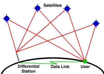
A Differential Global Positioning System (DGPS) provides improved accuracy by using a reference GPS receiver (Reference Station RS) located at an accurately surveyed point, By comparing the coordinates of the known location with that predicted by the GPS, satellite range corrections can be determined and broadcast in real-time by a radio link to nearby users who use the corrections to significantly improve their positional calculations,
This overcomes most of the errors that are inherent in SPS, mainly the satellite clock and Ephemeris errors, as well as other factors that contribute to errors in GPS measurements. These factors include ionospheric noise, satellite clock error, and ephemeris errors.
A primary marine DGPS system monitors the corrections and contains backup facilities to provide consistent and reliable service.
DGPS operates in all areas and all weather conditions. The corrections can be used to accurately produce other marine navigation information such as speed, heading, distances to waypoints etc. Further, a marine DGPO, user system requires little modification to shipborne equipment and can use existing radio beacon transmission stations. Generally DGPS shore stations provide "free" transmission of data to ship borne equipment in an internationally accepted format known as RTCM SC104.
The essential function of the DGPS broadcast system is to continuously broadcast to the users the pseudo-range correction factors of all GPS satellites in view and provide quality analysis of this broadcast data in real-time.
Reference stations with precise known locations can calculate the errors associated with each satellite and advise the users of the corrections necessary to reduce the errors in the location calculation. The accuracy of users' GPS receivers equipped with differential correction receivers is improved to less than 10 meters error. The FTMB system provides the hardware and software for error reducing signal transmission for the use of vessels and other navigators.